.png)
'Extremely Dangerous' Cyclone 'Biparjoy' Approaches Coast, Putting Gujarat on High Alert; Flight Operations Affected in Mumbai
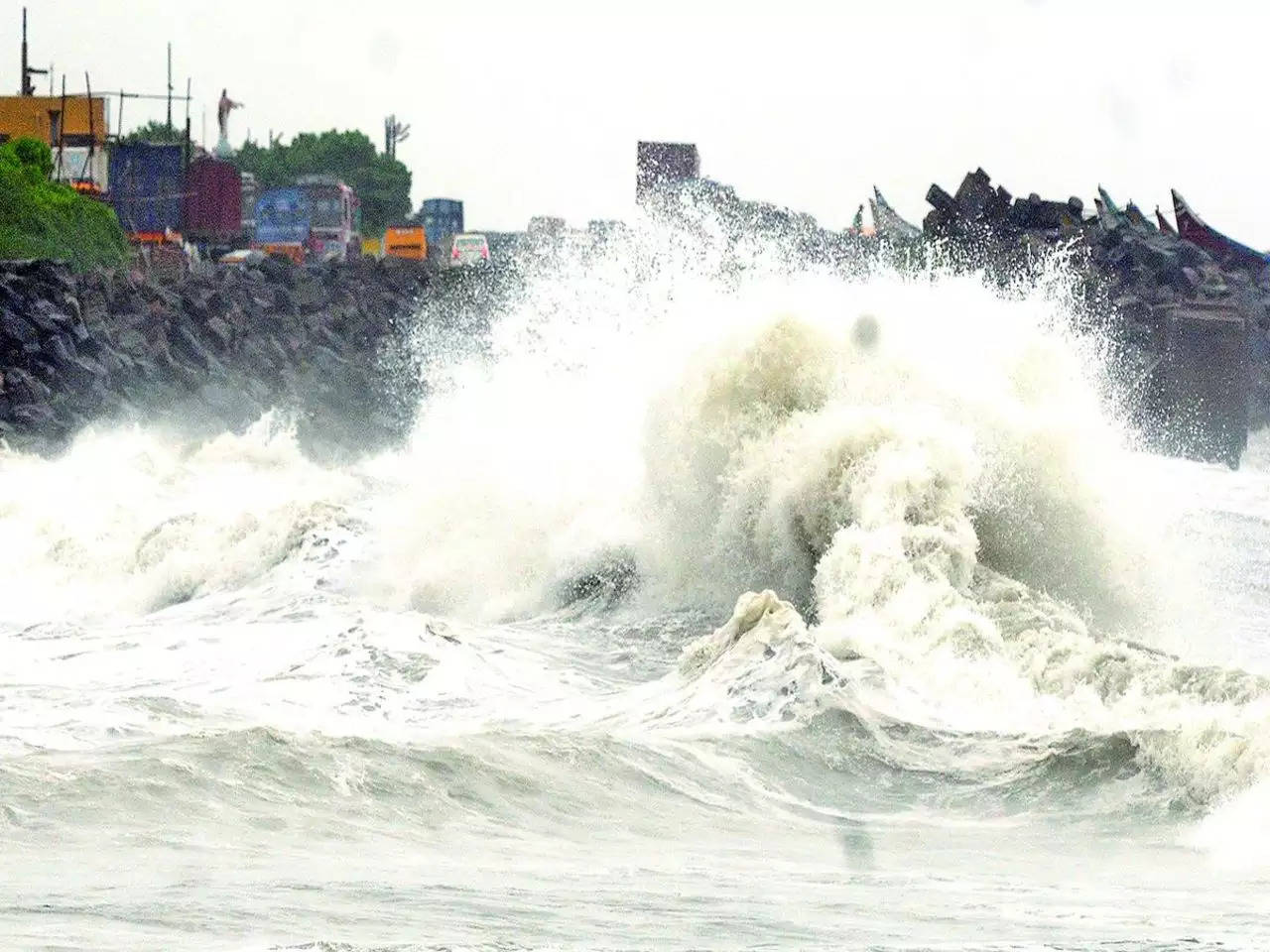
"Biparjoy," a very strong cyclonic storm, became a "very severe cyclonic storm" after intensifying "and would certainly impact the beaches of Pakistan's neighbouring countries and southwest Gujarat. An orange signal has been issued along and off the shores of Saurashtra and Kutch due to the impending landfall. In the upcoming days, it will become evident where the cyclone will make landfall.
Sea conditions along the shores of Saurashtra and Kutch will likely continue "tough to very rough" due to cyclonic activity "According to the India Meteorological Department, it was rough to high until Wednesday (IMD). While Biparjoy became a violent cyclonic storm, Mumbai also experienced high tides and heavy rainfall.
The weather service has advised a complete halt to fishing operations in the area till June 15 and asked fishermen to avoid the central Arabian Sea, the north Arabian Sea from June 12 to June 15, as well as the coastlines of Saurashtra and Kutch, until then. IMD also recommended that seafarers return to the coast and prudently manage both offshore and onshore activity.
"In light of the foregoing, state governments are recommended to keep a careful eye on things, check the situation in their regions on a regular basis, and take the necessary precautions. District authorities have been informed accordingly, according to the IMD.
"BIPARJOY" CYCLONE MOVEMENT
By 4:30 on Sunday, the extremely dangerous cyclonic storm "Biparjoy" was moving 8 kmph northeast over the eastern central Arabian Sea.
According to the Met department, it is centred approximately 550 kilometres west of Bombay, 450 kilometres south-southwest of Porbandar, 490 kilometres south-southwest of Dwarka, 570 kilometres south-southwest of Naliya in Kutch, and 750 kilometres south of Karachi in Pakistan.
Between Mandvi (Gujarat) and Karachi (Pakistan), around noon on June 15, a very severe cyclonic storm with a maximum sustained wind speed of 125-135 kmph gusting to 150 kmph is expected to cross Saurashtra and Kutch and adjacent Pakistan coasts.
As the storm's centre (or "eye") sweeps across the coast, a cyclone is considered to have made landfall after intensifying over the ocean.
In Gujarat, extensive destruction is anticipated.
On June 15, damage may occur in a number of Gujarati districts, including Kutch, Devbhumi Dwarka, Porbandar, Jamnagar, Morbi, Junagarh, and Rajkot.
According to a report by the news agency IANS, expected destruction includes the demolition of thatched and kutcha dwellings, damage to pucca houses, uprooting of power and communication poles, and potential dangers from flying objects.
Transportation infrastructure might also be affected, and substantial harm to orchards, plantations, and crops is predicted. Small boats and other vessels may be in danger because of the extreme reduction in visibility in these regions.
ACTIONS TAKEN BY THE GUJARAT GOV
Before the extremely dangerous cyclonic storm Biparjoy makes landfall on the state's coast, the Gujarati government is deploying NDRF and SDRF personnel in coastal areas and will erect shelters in six districts.
Senior ministers of the state cabinet have been given the responsibility of advance planning and disaster management by Chief Minister Bhupendra Patel. The district system will receive direction and cooperation from these ministers.
The assigned ministers are as follows: Rishikesh Patel for Kutch District, Praful Bhai Pansheriya and Kanubhai Desai for Morbi, Raghavji Patel for Rajkot District, Kuvarji Bavaliya for Porbandar, Mulu Bhai Bera for Jamnagar District, Harsh Sanghavi for Devbhumi Dwarka, Jagadish Vishwakarma for Junagadh District, and Purushottam Solanki for Gir Somnath. All of these ministers have been told by Chief Minister Bhupendra Patel to get to their respective areas as soon as possible.
According to Relief Commissioner Alok Pandey, teams from the National Disaster Response Force (NDRF) and State Disaster Response Force (SDRF) have been deployed along the coast and different departments, such as agriculture, fisheries, and health have been ordered to coordinate their efforts.
For individuals who live within a 5–10 km radius of the shore who will be relocated to safer areas, the government will erect shelter buildings in the six districts.
On Sunday, Ajay Bhalla, the Union Home Secretary, evaluated how well the Gujarat administration and various branches of the federal government were prepared to handle the approaching Cyclone Biparjoy.
INFLUENCE ON WEATHER
On June 14 and 15, the IMD has issued heavy rainfall warnings for the districts of Kutch, Devbhumi Dwarka, Porbandar, Jamnagar, Rajkot, Junagadh, and Morbi.
On June 14, it's expected that some areas will see "heavy to very heavy" rainfall, and on June 15, some areas will experience "very heavy" rainfall. According to the IMD advisory, the remaining districts in the Saurashtra and north Gujarat regions are also predicted to see very high rainfall on that day.
A runway at the Mumbai airport was closed owing to bad weather brought on by Cyclone "Biparjoy," which resulted in the cancellation and delay of some flights.
Also Read: Flight Operations Are Impacted by the Closure of the Main Runway at Mumbai Airport
IMD FORECAST FOR THE NEXT 4 DAYS FOR THE REST OF INDIA
Northeast India: Over the next four days, widespread light to moderate rainfall with a few isolated heavy to very heavy falls is extremely possible, according to the IMD's most recent report.
East India: According to the weather service, isolated areas of Sub-Himalayan West Bengal and Sikkim will likely see significant rainfall within the next 36 hours, followed by three days of heavy to very heavy rainfall.
Throughout the following three days, isolated areas across the Andaman and Nicobar Islands are also highly likely to see heavy rainfall.
Northwest India: Over the next three to four days, localised hailstorms are quite likely to occur over the states of Himachal Pradesh and Uttarakhand. On June 15, isolated areas of Rajasthan are extremely likely to experience severe thunderstorms with squalls.
West India: On June 15 and today, heavy rainfall is very possible in secluded areas of the Konkan and Goa.
On June 14, heavy to very heavy rain and extremely heavy rain are both quite likely to fall in remote areas of Saurashtra and Kutch.
South India: Today over Coastal Karnataka and isolated locations over Kerala throughout the following 36 hours, there is a very high likelihood of receiving heavy rainfall.
Warning for heatwave: For the next four days, isolated pockets of heatwave conditions are very likely to persist over Bihar, Jharkhand, and coastal Andhra Pradesh. From June 13 onward, they are also very likely to continue over south Haryana-Delhi, south Uttar Pradesh, Gangetic West Bengal, and Odisha.